Photo Control Surveying
Spurrier land surveying have land surveyors who perform photo control land surveys which produce a list of coordinates over a photo map that lays out the boundary points of a property. If used correctly, aerial photo control land surveys can result in better engineering and save time and money 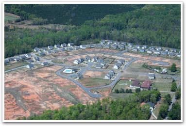 on repairs and improvements later. Photo control surveys are typically used during the planning stage of a project in which the needs are determined.
These surveys can reveal land use and patterns for regional planning, show suburban growth patterns, help with traffic engineering, and reveal parking patterns. If you are interested in a photo control land surveys, you can trust Spurrier Land Surveying to deliver your results quickly and efficiently. Spurrier Land Surveying offers land surveys in Elizabethtown, Bardstown, Hodgensville, Radcliff, Fort Knox, West Point, Louisville, Shepherdsville, Boston, Lebanon Junction, Munfordsville, Upton, Sonora, Cecilia and all of Kentucky. Contact us for a free estimate today!